
Flood Hazard
THE FLOODPLAIN
First of all, DON\’T BUILD IN A FLOODPLAIN!!! But, if you choose to ignore this very good advice, at least familiarize yourself with the following.
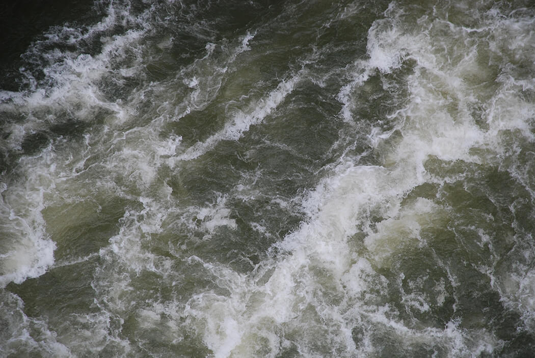
Floods happen in all 50 states. They will occur along the coasts as a result of tidal surge induced by hurricanes and strong storms. They will occur along all rivers and creeks and streams and gullies and ravines, when heavy rains cause those waterways to overflow their banks. Flash-flooding is considered common if unpredictable in low-lying deserts and canyons, and can bring a wall of water 10 to 20 feet high. On mountains, flooding can be caused by the sudden release of winter lakes pent-up behind ice dams, or simply the rapid melting of snow.
Even high altitude communities are at risk when they are built on hillsides below natural lakes, or abandoned quarries and mines. Water from snowmelt, streams, and rainfall can fill those pits and tunnels, unobserved. A natural or man-made event can trigger a sudden release, causing millions of gallons of water to wash-over, and wash away the unsuspecting town below.
Flood-type disasters also occur in other forms. The over-saturation of earth can cause mudslides. The tentative and precarious piling of snow can result in an avalanche. The pressure wave from an ice flow or landslide can force water to rapidly escape its shoreline. A dam or levee could break, the forces of nature overwhelming that man-made structure.
Types of Floods
- Abandoned Mine Tunnels.
- Abandoned Quarries.
- Avalanche.
- Flash Flooding.
- Ice Dam Collapse.
- Ice flows.
- Lakes and Ponds.
- Mountain Lakes.
- Mudslides.
- Pressure wave.
- River Systems.
- Tidal Surge
The occurrence of any one of these flood types is damaging. The combination of more than one could be devastating. For example, look at infamous Hurricane Katrina. Uncommonly low air pressure within the storm lifted a dome of water, and dragged it along until it was dropped on the land – tidal surge. Record-breaking rainfall caused all freshwater reservoirs to wash over their banks – overflow. Though the storm moved inland, the deluge did not decrease. Miles from the coast, vast amounts of rain water fell into rivers and streams, where it rushed downhill straight back to just-flooded regions – a flash flood. The concentration of so much water in one place collapsed private ponds and ruptured levees – failure of man-made structures.
Because flooding can result from so many different causes, and in such disparate regions, and because the comparative risk between those regions is so great, the Army Corps of Engineers, FEMA and the USGS has devised a series of maps which display the flood hazard area, or floodplain, for every region in the country where flooding is a possibility.
You need to know this. Information regarding the relationship between a parcel of land and the floodplain is available from several sources.
- Local Building Department.
- Local Zoning Department.
- Local Flood Hazard Boundary Maps FHBM.
- Local Flood Insurance Rate Maps FIRM
- Local Floodplain Management Office.
- The Local Emergency Management Office
- The Army Corps of Engineers.
- Federal Emergency Management Agency FEMA
Ask to see a flood map for your community. A map of projected flood elevations might be available for your specific neighborhood or land parcel.
To enhance the usefulness of these maps floodplains are further divided into regions which are named according to how often a flood might be expected to occur within that region. Typically defined regions are :
- 25 Year Floodplain.
- 50 Year Floodplain.
- 100 Year Floodplain.
- 200 Year Floodplain.
- 500 Year Floodplain.
You need to know this. Floodplain regions, such as the 100 year floodplain, are so named based on probability, not certainty. It is probable that a flood will happen within that region, on average once every hundred years. However, the name 100 year floodplain does not imply a guarantee that, once flooded, a region will not flood again for a hundred years.
A client, one of my regular customers, asked me to meet him to discuss the construction of his personal home. On arrival, I observed beautiful farmland with open spaces, rolling hills, and….. a river. He guided me to his chosen home-site, a sandy promontory with a mature stand of trees on the very edge of the river. He explained to me that he had played here is a boy, it was his favorite place in the world, and he wanted to build his last home here. The setting was quite beautiful. Majestic oak and hickory trees stretched their canopies far out over the current. Wild ferns unfurled between moss-covered rocks in the cool shade of this quiet preserve. But I was still nervous. This home would be built right next to the river, and I was certain it was within some sort of floodplain. “Yes,” he said, “it\’s in the hundred year floodplain, but I\’m not worried, because we had our hundred year flood last year, so we’re done.” He was right about that. The year before had seen a flood, which the newspapers proclaimed as Rain For A Hundred Years. So,… he felt safe…. I felt worried. I knew that floods don\’t follow a schedule, and just because we had one big flood the year before was no reason to gamble that we wouldn\’t have another one soon. The fact is, I was so worried that I declined the project. He wasn\’t angry. He just got somebody else to draw his plans and built anyway. Eleven months later the newspapers proclaimed Rain For A Hundred Years AGAIN. This time he wasn\’t so lucky. The river’s rushing torrent eroded the shoreline and made quick work of carrying away that shaded, sandy promontory and the house on its crest.
Flood Terms
- Base Flood Depth BFD The depth shown on the Flood Insurance Rate Map that indicates the anticipated depth of water above the highest adjacent submerged ground.
- Base Flood Elevation BFE The computed elevation to which floodwater is anticipated to rise during the base flood. Base Flood Elevations (BFEs) are shown on Flood Insurance Rate Maps (FIRMs) and on the flood profiles. The BFE is the regulatory requirement for the elevation or floodproofing of structures. The relationship between the BFE and a structure\’s elevation determines the flood insurance premium.
- Buffer Zone FEMA recommends that a 250 foot buffer zone be observed in conjunction with typically ambiguous Q3 Flood Data. The buffer zone is 250 feet outside of the floodplain boundary line. Because of the very small scale of the digital Q3 Flood Data, it cannot be used to determine absolute delineations of flood risk boundaries. It is especially important to understand the \”buffer\” that FEMA recommends users apply to the floodplain boundary. Users should refer to the official hardcopy map if a site of interest falls within the buffer zone.
- Community Rating System (CRS) is a voluntary incentive program that recognizes and encourages community floodplain management activities that exceed the minimum NFIP requirements. As a result, flood insurance premium rates are discounted to reflect the reduced flood risk resulting from the community actions meeting the three goals of the CRS:
-
- Reduce flood losses.
- Facilitate accurate insurance rating.
- Promote the awareness of flood insurance.
- Department of Homeland Security (DHS) The Department of Homeland Security is the parent organization for all other health, protection, and safety organizations in the country. The National Strategy for Homeland Security and the Homeland Security Act of 2002 served to mobilize and organize our nation to secure the homeland from terrorist attacks. But, the DHS mission extends far beyond that. One primary reason for the establishment of the Department of Homeland Security was to provide the unifying core for the vast national network of organizations and institutions involved in efforts to secure our nation from all threats. The DHS mission statement outlines methods to respond to disasters resulting from such things as acts of terrorism, acts of nature, earthquakes, fires, floods, hazardous spills, hurricanes, man-made disasters, and tornadoes. To accomplish this, the strategic goals of the DHS include :
-
- Awareness — Identify and understand threats, assess vulnerabilities, determine potential impacts and disseminate timely information to our homeland security partners and the American public.
- Prevention — Detect, deter and mitigate threats to our homeland.
- Protection — Safeguard our people and their freedoms, critical infrastructure, property and the economy of our Nation from acts of terrorism, natural disasters, or other emergencies.
- Response — Lead, manage and coordinate the national response to acts of terrorism, natural disasters, or other emergencies.
- Recovery — Lead national, state, local and private sector efforts to restore services and rebuild communities after acts of terrorism, natural disasters, or other emergencies.
- Service — Serve the public effectively by facilitating lawful trade, travel and immigration.
- Organizational Excellence — Value our most important resource, our people. Create a culture that promotes a common identity, innovation, mutual respect, accountability and teamwork to achieve efficiencies, effectiveness, and operational synergies
- Elevation Certificate A community\’s permit file must have an official record with documentation that new buildings and substantial improvements to buildings and facilities in all identified Special Flood Hazard Areas (SFHAs) are properly elevated. This elevation information is needed to show compliance with the floodplain management ordinance. FEMA encourages communities to use the Elevation Certificate developed by FEMA to fulfill this requirement since it also can be used by the property owner to obtain flood insurance. Communities participating in the Community Rating System (CRS) are required to use the FEMA Elevation Certificate.
Federal Disaster Assistance is usually a loan that must be paid back with interest. Federal Disaster Assistance is only available if the President declares a disaster. More than 90 percent of all disasters in the United States are not Presidentially declared. Flood insurance pays even if a disaster is not declared.
- FEMA The Federal Emergency Management Agency is part of the U.S. Department of Homeland Security (DHS). The primary mission of the Federal Emergency Management Agency is to reduce the loss of life and property and protect the Nation from all hazards, including natural disasters, acts of terrorism, and other man-made disasters, by leading and supporting the Nation in a risk-based, comprehensive emergency management system of preparedness, protection, response, recovery, and mitigation. Disaster can strike anytime, anywhere. It takes many forms — a hurricane, an earthquake, a tornado, a flood, a fire, a hazardous spill, an act of nature, or an act of terrorism. It builds over days or weeks, or hits suddenly, without warning. Every year, millions of Americans face disaster, and its terrifying consequences.
FEMA’s mission statement includes :
- Administering the national flood insurance programs
- Advising on building codes
- Advising on flood plain management
- Teaching people how to get through a disaster
- Helping equip local and state emergency preparedness systems and organizations.
- Coordinating the federal response to a disaster.
- Making disaster assistance available to states, communities, businesses and individuals.
- Training emergency managers.
- Supporting the nation\’s fire service.
- Administering the national crime insurance programs.
The range of FEMA\’s activities is broad and spans the life cycle of disasters.
- Flood Hazard Boundary Map FHBM. Flood Hazard Boundary Maps are old-style flood maps that used to be produced by FEMA, and have been replaced by FIRM maps. The FBFM is a version of a flood map that shows only the floodway and flood boundaries.
- Flood Insurance Rate Map FIRM. Produced by FEMA, this is the official map of a community on which FEMA has delineated both the special hazard areas and the risk premium zones applicable to the community. FIRM maps show flood risk zones and their boundaries, and may also show floodways and Base Flood Elevations (BFEs). More recent flood map products include digital FIRMs, which are created using computed based methods and can be incorporated into a community\’s Geographic Information System (GIS). FEMA has also produced Q3 Flood Data, which includes certain features of the FIRM, and may be used for insurance purposes and planning activities. The Q3 cannot be used as the official NFIP map for site design or flood risk determinations.
- Geographic Information System (GIS) a computer-based system to capture store, retrieve, manipulate, analyze and display geographical and topographical information. This information can be used for flood hazard mapping, and to increase flood control, prediction, action, and awareness.
- National Flood Insurance Program NFIP
A homeowner’s policy does not usually cover flood damage. Flood Insurance covers losses to your property caused by flooding. From structural and mechanical damage to debris cleanup, your investment is protected by a flood insurance policy.
- Non-Special Flood Hazard Areas (NSFHA) are low to moderate risk flood zones. On the FIRM, they are unshaded or lightly shaded. Historically, 30% of all claims occur in these areas. A Preferred Risk Policy may be available.
- Q3 Flood Data The average individual will never have a need for this information, but should still be familiar with it. The Q3 Flood Data product is a digital (computerized) representation of certain features of FEMA\’s Flood Insurance Rate Map (FIRM) product. However, it is not a substitute for FIRM paper maps (see Buffer Zone above) and will always be superseded by FIRM hard copy. Q3 Flood Data integrates with desktop mapping and Geographic Information Systems technology. Q3 Flood Data is intended for government level use and for general reference only. The digital Q3 Flood Data are designed to serve FEMA\’s needs for :
-
- FEMA\’s Response and Recovery activities after a flood disaster
o Promotion of flood insurance policy marketing initiatives, including National Flood Insurance Program activities, and risk assessment.
-
- Assistance in floodplain management activities at the local level .
The data are expected to be used for a variety of planning applications including :
o Broad-based review for floodplain management.
o Land-use planning.
o Commercial site analysis.
o Insurance target marketing.
o Natural resource/environmental analyses.
o Real estate development and targeting.
Q3 Limitations : Because of the very small scale of the digital Q3 Flood Data – USGS 1:24,000 – it cannot be used to determine absolute delineations of flood risk boundaries. (see Buffer Zone above) It is especially important to understand the \”buffer\” that FEMA recommends users apply to the floodplain boundary. The buffer is 250 feet outside of the floodplain boundary line. Users should refer to the official hardcopy map if a site of interest falls in the buffer.
The digital Q3 Flood Data contain the following:
-
-
- 1-percent (100-year) and 0.2-percent (500-year) annual chance floodplain boundaries (including water current velocity zones),
- flood insurance zone designations,
- floodway boundaries (where available),
- political boundaries (State, county, and community),
- community and map panel identification numbers,
- United States Geological Survey (USGS) 1:24,000 scale topographic map
- Coastal Barrier Resources System areas.
-
The digital Q3 Flood Data do not contain the following data features that are shown on the official paper Flood Insurance Rate Map:
-
-
- Hydrographic features (streams and river, lake and coastal shorelines),
- Base flood elevations,
- Cross section lines,
- Roads, road names, or address ranges, and
- Locations, elevations and descriptions of benchmarks and elevation reference marks.
-
- Special Flood Hazard Areas (SFHA) SFHA’s are the flood zones that have the greatest risk of flooding. They are darkly shaded areas on FIRM maps. During a 30-year mortgage, there is a 26% chance of flooding in these areas and only a 4% chance of fire in the same period.
SFHA designations start with the letters \”A\” (Riverine/Inland Group) or \”V\” (Coastal Group) – indicated by tidal floods with water current velocity.
- United States Geological Survey USGS is the Nation\’s largest water, earth, biological science, and civilian mapping agency. The USGS collects, monitors, analyzes, and provides scientific understanding about natural resource conditions, issues, and problems. Through cooperation with departments of the United States government, such as FEMA, the USGS is instrumental in preparation of flood hazard maps, data and statistics.
Occurrence of Floods.
The most severe flooding usually occurs in late spring and early summer as a result of snowmelt, heavy rainfall from thunderstorms, ice jams, and any combination of these. But, warm weather has no monopoly. Major winter storms tempered by unseasonably warm air can create havoc with uncharacteristic rainfall. Though statistics give some insight into the likelihood of flooding, nature doesn\’t read the almanac.
Flood Facts
Anyone considering building in a floodplain, should know some of the things to be dealt with. If your home is in an area about to be flooded, you either have to get in to get your things, or you have to get out. In either case, it will probably involve a vehicle.
You need to know this.
- Six inches of water will reach the bottom of most passenger cars causing loss of control and possible stalling. A stalled vehicle puts the driver and passengers at risk of electrocution, as well as being attacked by snakes, alligators, fire ants, wild or panicked animals, and other dangers that might float by.
- A foot of water will float many vehicles. A floating vehicle can quickly become an overturned vehicle. It is difficult, sometimes impossible to escape from an overturned, floating vehicle.
- Two feet of rushing water can carry away most vehicles including sport utility vehicles (SUV’s) and pickup trucks. A vehicle carried in a rushing torrent becomes part of the floating debris. If that vehicle collides with anything heavy such as a log, or the torn away remnants of a destroyed home the results could be fatal.
Permit Requirements
In almost every area nationwide, zoning ordinances require a permit for any activity performed in a floodplain. This includes grading, filling, and the construction of homes and businesses. Noncompliance with these ordinances is taken so seriously that any infringing structures or landscaping treatments could be torn down or undone at the owner’s expense, without the owner\’s consent.
Construction Requirements
Water in motion, even slowly, is one of the most irresistible forces on the planet. The structural considerations for a “normal” house are nothing compared to those for a home in a flood hazard area. Some considerations for making a structure flood resistant are:
- FEMA Requirements.
- Pro-active development : Many forward thinking, fast-growing cities and communities are implementing a requirement that, for new subdivisions and subdivided land parcels, developers and builders must fund the provision and future maintenance of flood defense works, and sustainable drainage measures to avoid adding to flood risk elsewhere.
- Flood-proofing.
-
- Dry Floodproofing involves methods to thoroughly waterproof a structure so that its interior surfaces will remain completely dry during flooding. Dry floodproofing is appropriate primarily for slab-on-grade buildings with concrete or solid masonry walls. Concrete and masonry are easier to seal, more resistant to flood damage, and stronger than other conventional construction materials. If you dry flood-proof a “substantially damaged” or “substantially improved” building (as defined by the National Flood Insurance Program regulations) or a newly constructed building, and if the building’s lowest floor (including any basement) is below the Base Flood Elevation (BFE) shown on the Flood Insurance Rate Map (FIRM) for your community, your dry floodproofing must be certified as providing protection from the BFE. To obtain this certification, you must flood-proof your building to a height at least 1 foot above the BFE. Check with your local floodplain manager or building official for more information. The height of your dry flood-proofing should not exceed 3 feet. The pressures exerted by deeper water can cause walls to buckle or collapse. Before you use dry flood-proofing to protect against greater flood depths, have a structural engineer evaluate the strength of your walls. If your dry flood-proofing measures require human intervention, such as placing shields over doors and windows before floodwaters arrive, you should have an operations and maintenance plan that describes all the actions that must be taken and lists the persons who are responsible. It must also include a schedule of periodic maintenance that states how often the dry floodproofing measures will be inspected and who will perform the inspections.
o Wet floodproofing involves methods in which it is accepted that the interior of the building will be flooded. Flood damage is kept to a minimum by using special water-resistant construction materials in the lower levels of the building. Wet floodproofing is frequently the only method of controlling or reducing flood damage to existing buildings in areas subject to flooding. It is seldom advocated for new buildings because of the cost of drying out, the delay in return to use, and the clean-up required after a flood.
- Building Requirements.
o Elevate and reinforce the home.
o Elevate the appliances, furnace, water heater, and electric panel.
o Elevate electric outlets and switches.
o Install \”check valves\” in sewer traps to prevent floodwater from backing up into the drains of the home.
o Construct barriers (levees, berms, floodwalls) to stop floodwater from entering the building.
o Seal walls in basements with waterproofing compounds to avoid seepage.
o Secure all fuel tanks against floating.
- On-site sewage tanks.
- On-site fuel tanks – Make sure vents and fill-line openings are above projected flood levels. Propane tanks are the property of the propane company. You’ll need written permission to anchor them. Ask whether the company can do it first.
- Buried.
- Ground supported
Remodeling Techniques.
o Thoroughly waterproof the basement.
o Seal openings below the flood line.
o Construct floodwalls around basement doors and window wells.
o Install \”check valves\” in sewer traps to prevent floodwater from backing up into the drains of the home.
o Install a floating floor drain plug at the current drain location. If the floor drain pipe backs up, the float will rise and plug the drain.
o Pumping systems.
Maximum Building Envelope.
o Maximum height above the floodplain.
o Maximum exposure to force of floodwaters
- Elevation (altitude) Above Floodplain=12” minimum. The minimum distance from the top of the floodplain to the bottom of the floor system which supports the first residential level, must be at least 12 inches. Other considerations might apply. Ask your local building officials.
- Occupancy Restrictions.
o No residential use below flood level.
o Only Storage is allowed below flood level.
Flood Defense.
o Levees.
o Pumping Systems.
o Waterproofing.
House to Ground Connection.
o Load Bearing Walls
o Poles, Pilings, Stilts
o Anchor Bolts and Rods.
o Hold-Down Anchors.
Lateral Shear Resistance.
o Reduced Surface Area. The structural envelope, the main body of the house, must be able to hold together against the pressure of rushing water. A primary method to accomplish this is by minimizing the area of the structure that is actually in the flood water. By building a house on poles, pilings or stilts the surface area against which the water might push is significantly reduced.
o Breakaway Wall, sometimes called a Blow-out Wall –A wall that is not part of the structural support of the building and is intended through its design and construction to collapse under specific lateral loading forces such as moving flood waters, without causing damage to the elevated portion of the building or supporting foundation system.
o Bracing involves strengthening walls so that they can withstand the pressures of flood waters and the impacts of flood-borne debris.
- Buoyant Forces. Though a house is heavy, if it\’s built well and tightly, it will exhibit tendencies similar to a floating vessel. The building code requires specific types of connections – anchors, rods, pins and straps – to counter and resist this float-ability.
- Uplift. As water rushes under the house and strikes against the pilings it has a tendency to pile-up and push up against the structure. The ebb and flow of the current can alter in rapid succession, getting stronger then weaker. This constant oscillation, even over a short period of time can weaken structural connections, and eventually cause the house to break free and float away.
- Engineered Fill A process where dirt, which may be liquefied or washed away during a flood, is removed by excavation and replaced with a specific type of dirt that, once properly compacted, will resist saturation and maintain structural cohesion, even in the midst of flooding.
- Engineered Mound A process where a specific type of dirt is compacted in a specific manner to construct a mound, which will resist saturation and maintain structural cohesion, even in the midst of flooding; and the top of which meets the minimum requirements for elevation above the floodplain; and is suitable for the construction of a slab-on-grade structure.
- Floodplain Management Cooperation Results come better and sooner when everyone is working toward the same goal. By combining the efforts of individuals, developers, builders, communities, building departments, planners, code writers and government agencies, good and comprehensive, long-term plans can be devised, which will help protect our homes and businesses, our natural resources, our towns and cities, even counties and entire collective regions.
After a Flood
You don\’t “just go home” to a house that\’s been flooded. Even if the structure did not float away, the contents may still be soaked and ruined. “Drying-out” is not all there is to do. Just a few possible considerations are :
[columnize]Air-conditioning duct work destroyed.
Animals that crawled in and died.
Animals that crawled in and left their waste behind.
Appliances destroyed.
Dead animals that floated downstream to settle on your property, such as cows, horses, pets and other animals.
Debris that floated downstream to settle on your property. This could even be someone else\’s entire house.
Electrical system destroyed.
Fire ants that floated downstream and have established a new colony in your home.
Fish, turtles, snakes, alligators, and other aquatic creatures that became trapped and died, or have moved in to stay.
Human bodies lost in upstream tragedies.
Leftover pools, infested with mosquitoes.
Mold can become established quickly in dank, wet environments. Mold can be a serious health hazard.
Mud that settled in.
No food, water, refrigeration, personal items, or possessions.
No Internet, no Cable TV, no Video Games.
No working bathroom facilities.
Oil and fuel deposits all which floated downstream from road and pumping station runoff, and ruptured fuel lines and tanks.
Raw sewage inadvertently discharged by overwhelmed upstream treatment systems.
Security system inoperative.[/columnize]
Federal Disaster Assistance
A very common misconception is that Federal disaster assistance is available to flood victims any time for free. This is not true.
You need to know this.
Federal disaster assistance is only available if the President declares a disaster. More than 90 percent of all disasters in the United States are not presidentially declared. Flood insurance pays even if a disaster is not declared.
Even in a declared state of emergency, Federal disaster assistance is usually a loan that must be paid back with interest. For example : a thirty year $50,000 loan at 4% interest, would have a monthly payment of about $240 a month – $2,880 a year. Compare that to a $100,000 flood insurance premium, which is about $33 a month – $500 a year.
This is what can happen if you ignore this advice. In the United States almost all of us share one thing that is both a blessing and a problem – our standard of living. Our blessing is : we can afford to buy so many possessions, and we can afford to consume so much, and it\’s been that way for such a long time that we take it completely for granted,….. and that\’s our problem. We barely give a second thought to what we have, and we think even less about what we could lose. The following list contains items which are washed away by the average flood.
- Family members.
- Pets.
- Livestock.
- The House.
- Medications.
- Family Papers.
- Children\’s handiwork.
- Finger-painting.
- homework projects
- kindergarten projects.
- Refrigerator art.
- Letters to Santa Claus.
- Handmade cards for special events such as birthdays, Mother\’s Day, Father\’s Day, and Christmas.
- Birth certificates.
- Marriage licenses.
- Diplomas.
- Social Security Numbers.
- Bank Account Numbers
- Checkbooks.
- Car titles of ownership.
- Property titles of ownership.
- Stock certificates and portfolios.
- Accounting ledgers
- Cash
- Access Information
- Personal Identification Numbers.
- Passwords.
- Art work.
- Paintings.
- Photographs.
- Film.
- Prints.
- Carvings.
- Sculptures.
- Statuary.
- Children\’s handiwork.
- Keyes to vehicles and property
- Books and Bound Volumes.
- Scrapbooks.
- Baby books.
- Wedding albums.
- Family Bible.
- Magnetic media.
- Audiotapes.
- Videotapes.
- Favorite movies.
- Family videos
- Computer disks and hard drives.
- Laser media.
- Compact discs.
- Favorite artists.
- Favorite mixes.
- Computer data
- digital video discs.
- Favorite movies.
- Family videos
- LP laserdiscs
- Compact discs.
- Electronics.
- Videogames.
- Game cartridges and discs.
- Game controllers.
- Game based units.
- Televisions.
- Video projectors.
- Audio Video Players such as stereos, VCRs and DVD players.
- Personal communications devices.
- cell phones
- pagers
- beepers
- headphones and earpieces
- Videogames.
- Appliances.
- Kitchen.
- Household
- Laundry.
- Lawn and garden.
- Vehicles
- Automobiles and Trucks.
- Pleasure Vehicles.
- Touring boats
- Ski Boats.
- Fishing boats.
- Jet skis.
- Paddleboats.
- Children\’s electric vehicles.
- Go karts.
- Bicycles.
- Tricycles.
- Motorcycles.
- Hang gliders.
- Utility vehicles.
- All-terrain vehicles.
- Utility trailers.
- Lawnmowers.
- Golf carts.
- Portable Structures.
- Tents.
- Portable Gazebos.
- Portable Pavilions.
- Portable Storage Buildings
- Portable Vehicle Covers and Enclosures.
- Interior furnishings.
- All furniture.
- Lamps and light fixtures.
- Decorative accessories such as candlesticks, picture frames and flower vases.
- Rugs and carpets.
- Bed and Bath linens.
- Window treatments.
- Exterior furnishings.
- Pool equipment.
- Deck and a Porch Furniture
- Lawn Furnishings
- Declarations and Ornaments.
- Personal Items.
- Clothing.
- Shoes.
- Underclothes
- Hygiene Necessities
- bath soap and body wash.
- Shampoo.
- Bath oils.
- Lotions.
- Antiperspirants and deodorant.
- Tampons and Sanitary Napkins
- Beauty Needs.
- Hairdryers
- Make-up.
- Hairspray and hair gel.
- Fragrances, Cologne and Perfume.
- brushes and combs.
- Hair-bands and hair clips.
I\’ll bet if I put my mind to it I could think of a lot more, but you get the idea. To intentionally build in an area susceptible to flooding is an invitation to Disaster. Here are a few last tips and reminders.
- Flood-proofing Is Expensive.
- Flood Resistant Construction Is Expensive.
- Flood Drainage Maintenance Is Expensive
- Flood Preparation Is Expensive.
- Flood Cleanup Is Expensive.
- Family Counseling After the Trauma of a Flood Is Expensive.
- Flooding Is almost Inevitable.
Still thinking about building in a flood hazard area? Then at the very least, you should consider getting Flood Insurance.
[hbt_cta]
Tiny House Living
Tiny House Living
Concrete – First Look
Concrete – First Look
Wildfire (Will-Burn) Zones
Wildfire (Will-Burn) Zones

N-3 / MIND & BODY : The Dream Is Created...
N-3 / MIND & BODY : The Dream Is Created...

M-5 / Money : Borrowing, Managing, Repaying, ...
M-5 / Money : Borrowing, Managing, Repaying, ...
L-12 / BEADS KEYSTONE 14 Critical Questions t...
L-12 / BEADS KEYSTONE 14 Critical Questions t...

NECROSIS for BEGINNERS
NECROSIS for BEGINNERS
Index
Index

Secret Rooms : A Not-So-Secret Guide
Secret Rooms : A Not-So-Secret Guide
PANDEMIC PRICING AND HOMEBUILDING
PANDEMIC PRICING AND HOMEBUILDING
Home-building can be a String of Bad Decision...
Home-building can be a String of Bad Decision...

Be IndistrActable
Be IndistrActable

Codes Changing for Climate Change
Codes Changing for Climate Change

YOUR OLDIE-BUT-GOODIE DAYS : Aging-In-Place
YOUR OLDIE-BUT-GOODIE DAYS : Aging-In-Place

Favored Formula for Life
Favored Formula for Life

CLOSETS : Her Heart’s Desire
CLOSETS : Her Heart’s Desire